|
Trent
Houseboat Rentals helps when it was time to plan your
Kawartha and Trent Severn Waterway family vacation. The
Trent Severn Waterway is Central
Ontario's 387 kilometers of waterway utilizing
41 locks, a marine railway and 2 hydraulic lift locks raising
navigation 180 meters above Lake Ontario and 80 meters above
Georgian Bay, at Balsam Lake. Here we present
you with many of the amenities and services available along. At the
heart lay the Kawartha lakes, bounded by Rice Lake and the
Trent River to one side and Lake Simcoe all the way to Georgian
Bay on the other side. |
The
Trent Severn Waterway, Houseboat Vacation Questions
When it was time to
plan our Kawartha and Trent Severn Waterway family vacation here is the
criteria
we used to decide on a houseboat rental. Hope this helps with
your decision! We have found the Internet to have sites that are a little
misleading and you need to ask the right questions to get what
you are
looking
for and believe you are ordering.
| |
Choose the right company for your vacation. |
| 1. |
Are they
professional, they let professionals like major magazines
or other media speak for them, and they
only list the pertinent facts? |
| 2. |
Do they
list numerous testimonials from satisfied clients? |
| 3. |
Do they
need to advertise other businesses or are they specialized
and stand alone? |
| 4. |
Do they
have printed colour brochures, videos or other demonstration
tools? |
| 5. |
Do they
have a
photo gallery of the region's tourist attractions and their
boats? |
| 6. |
Is their
web site easy to navigate and well organized for you? |
| 7. |
Do they
have sufficient boats available or simply talk the talk? |
| 8. |
Do they
offer multiple means of contact, email, 800 number, address
and map? |
| 9. |
On
your initial contact do you get a good
first impression of the company? |
| 10. |
Is the
information given factual or meant to mislead. For example
there can only be one with the most houseboats to rent so
ask the question of all who make the claim or attempt to
make you believe the claim. |
|
If
your time permits we strongly recommend going up and down on
the Peberborough Hydraulic Lift Lock
or if not possible then try the one at Kirkfield. Having crossed
Lake Simcoe in a 40 foot cruiser during a mild storm I would
not recommend
entering the lake even on a 40 foot cruiser unless you are
100% sure the
weather conditions are perfect.
Need
a larger boat, we strongly recommend the advantages in renting
two smaller houseboats . Flexibility and ease of use
are achieved when one group wants to say, play golf and the
other wishes to go shopping. The smaller boats are easier to
maneuver, two can give equal or more space and allows for one
houseboat to be used as a socialize platform while the other
may be used for those who need to get their rest early. Just
makes more sense and may even be more economical.
Advertising
space is available on this site. Please contact
us with your company name and the type of business
you offer. Suitable companies will be contacted.
|
|
|
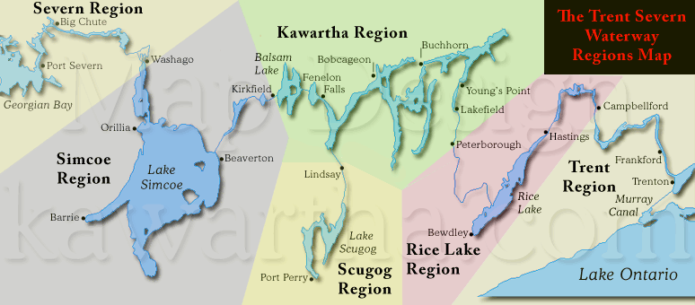
Mouse
over the regions on the map to view lock details
|
Central
Ontario encompasses
all six regions of Ontario's,
The Trent-Severn Waterway, offering a listing
service for residents
and tourists.
The
Trent Region starts at (1) Trenton on Lake Ontario and
ends at (13) Campbellford, other towns include Frankford, Belleville,
Brighton,
Picton and Bath..
The Rice Lake Region starts at (13) Campbellford
and ends at (19) Scott's Mill, other towns include Hastings,
Harwood
and Bewdley.
The Kawartha Region starts at (19) Scott's Mill
and ends at (36) Kirkfield, other towns include Peterborough,
Lakefield,
Young's Point, Burleigh
Falls, Buckhorn, Bobcageon and Fenelon Falls. Lakes include Katchawanooka,
Clear, Stony, Lovesick, Buckhorn, Pigeon, Chemong, Sturgeon,
Cameron and Balsam Lake.
The Scugog Region starts and ends at (33) Lindsay
allowing access to the Town of Port Perry and Lake Scugog.
The Simcoe Region starts
at (36) Kirkfield and ends at (42) Couchiching, other towns include Beaverton,
Barrie, Orillia, Washago and communities on the shores of Lake
Simcoe and Lake
Couchiching.
The Severn Region starts at (36) Couchiching
and ends at (45) Port Severn on Georgian Bay.
DETAILED
LOCK DESCRIPTION  <RETURN
TO PAGE TOP><VISIT
ALL OUR BUSINESS LISTINGS> <RETURN
TO PAGE TOP><VISIT
ALL OUR BUSINESS LISTINGS>
Lock
|
Station
|
Type
|
Chart
|
Lake
Ontario
KM - Miles
|
Region
|
GPS
(proximity)
| Lift
M - FT
|
| 1 |
Trenton |
Lock |
2021 |
0
- 0
|
Trent |
44.12071°N
- 77.59160°W
| 5.4
- 18 |
| 2 |
Sydney |
Lock |
2021 |
3.9
- 2.4
|
Trent |
44.13072°N
- 77.59152°W | 6.1
- 20 |
| 3 |
Glen Miller |
Lock |
2021 |
6.2
- 3.9
|
Trent |
44.15055°N
- 77.57970°W | 8.2
- 27 |
| 4 |
Batawa |
Lock |
2021 |
8.3
- 5.2
|
Trent |
44.16818°N
- 77.58638°W | 5.5
- 18 |
| 5 |
Trent |
Lock |
2021 |
10.3
- 6.4
|
Trent |
44.18484°N
- 77.59188°W | 5.5
- 18 |
| 6 |
Frankford |
Lock |
2021 |
11.7
- 7.3
|
Trent |
44.19776°N
- 77.59123°W | 4.9
-16 |
| 7 |
Glen Ross |
Lock |
2021 |
22.2
- 13.8
|
Trent |
44.26569°N
- 77.59697°W | 3.0
- 10 |
| 8 |
Percy
Reach |
Lock |
2021 |
40.7
- 25.3
|
Trent |
44.23592°N
- 77.78407°W | 6.0
- 20 |
| 9 |
Meyers |
Lock |
2021 |
42.5
- 26.4
|
Trent |
44.24690°N
- 77.80009°W | 4.9
- 16 |
| 10 |
Hauges
Reach |
Lock |
2021 |
45.0
- 28.0
|
Trent |
44.26730°N
- 77.79337°W | 7.3
- 24 |
| 11/12 |
Ranney
Falls |
Flight
Lock |
2021 |
47.8
- 29.7
|
Trent |
44.29031°N
- 77.80160°W | 14.6
- 48 |
| 13 |
Campbellford |
Lock |
2021 |
51.8
- 32.2
|
Trent
/Rice Lake |
44.31979°N
- 77.78615°W | 7.0
- 23 |
| 14 |
Crowe
Bay |
Lock |
2021 |
54.2
- 33.7
|
Rice Lake |
44.33516°N
- 77.77303°W | 7.6
- 25 |
| 15 |
Healy
Falls |
Lock |
2021 |
58.2
- 36.2
|
Rice Lake |
44.36891°N
- 77.77434°W | 6.6
- 22 |
| 16/17 |
Healy
Falls |
Flight
Lock |
2021 |
58.8
- 36.5
|
Rice Lake |
44.37283°N
- 77.77988°W | 7.3
- 24 |
| 18 |
Hastings |
Lock |
2022 |
82.3
- 51.1
|
Rice Lake |
44.30865°N
- 77.95703°W | 2.7
- 9 |
| 19 |
Scott's
Mill |
Lock |
2022 |
142.8
- 88.7
|
Rice
Lake /Kawartha
|
44.28926°N
- 78.30814°W | 2.4
- 8 |
| 20 |
Ashburnham |
Lock |
2023 |
144.5
- 89.5
|
Kawartha |
44.29924°N
- 78.30441°W | 3.7
- 12 |
| 21 |
Peterborough |
Lift
Lock |
2023 |
145.0
- 90.1
|
Kawartha |
44.30763°N
- 78.30098°W | 19.8
- 65 |
| 22 |
Nassau
Mills |
Lock |
2023 |
151.7
- 94.3
|
Kawartha |
44.36464°N
- 78.29033°W | 4.3
- 14 |
| 23 |
Otonabee |
Lock |
2023 |
152.6
- 94.8
|
Kawartha |
44.37248°N
- 78.28864°W | 3.7
- 12 |
| 24 |
Douro |
Lock |
2023 |
155.1
- 96.4
|
Kawartha |
44.38872°N
- 78.26960°W | 3.7
- 12 |
| 25 |
Sawer
Creek |
Lock |
2023 |
156.6
- 97.3
|
Kawartha |
44.40017°N
- 78.26287°W | 3.0
- 10 |
| 26 |
Lakefield |
Lock |
2023 |
158.9
- 98.7
|
Kawartha |
44.42001°N
- 78.27093°W | 4.8
- 16 |
| 27 |
Young's
Point |
Lock |
2023 |
168.1
- 104.5
|
Kawartha |
44.48823°N
- 78.23302°W | 2.2
- 7 |
| 28 |
Burleigh
Falls |
Lock |
2023 |
181.8
- 113.0
|
Kawartha |
44.55972°N
- 78.20815°W | 7.3
- 24 |
| 30 |
Lovesick |
Lock |
2023 |
18.7
- 114.8
|
Kawartha |
44.56196°N
- 78.25072°W | 1.1
- 3.5 |
| 31 |
Buckhorn |
Lock |
2023 |
194.2
- 120.7
|
Kawartha |
44.55558°N
- 78.34607°W | 3.5
- 11.5 |
| 32 |
Bobcageon |
Lock |
2025 |
222.4
- 138.2
|
Kawartha |
44.53906°N
- 78.54654°W | 1.6
- 5 |
- |
Port
Perry |
- |
2026 |
294.5
- 183.3 |
Scugog |
44.0905°N
-
78.9479°W
| - |
33 |
Lindsay |
Lock |
2026 |
251.6
- 156.3 |
Scugog |
44.35684°N
- 78.73527°W
| 2.1
- 7 |
| 34 |
Fenelon
Falls |
Lock |
2025 |
247.2
- 153.6
|
Kawartha |
44.53591°N
- 78.73718°W | 7.2
- 24 |
| 35 |
Rosedale |
Lock |
2025 |
252.9
- 157.2
|
Kawartha |
44.57171°N
- 78.77842°W | 1.2
- 4 |
| 36 |
Kirkfield |
Lift
Lock |
2025 |
272.6
- 169.4
|
Kawartha
/Simcoe |
44.58956°N
- 78.98955°W | 14.9
- 49 |
| 37 |
Bolsover |
Lock |
2025 |
284.9
- 177.0
|
Simcoe |
44.53457°N
- 79.07110°W | 6.6
- 22 |
| 38 |
Talbot |
Lock |
2025 |
286.5
- 178.1
|
Simcoe |
44.50959°N
- 79.10661°W | 4.3
- 14 |
| 39 |
Portage |
Lock |
2025 |
289.1
- 179.6
|
Simcoe |
44.50276°N
- 79.12626°W | 4.0
- 13 |
| 40 |
Thorah |
Lock |
2025 |
289.8
- 180.1
|
Simcoe |
44.49881°N
- 79.13262°W | 4.3
- 14 |
| 41 |
Gamebridge |
Lock |
2025 |
290.9
- 180.7
|
Simcoe |
44.48667"N
- 79.14889"W | 3.0
- 10 |
| 42 |
Couchiching |
Lock |
2028 |
337.8
- 209.9
|
Simcoe
/Severn |
44.76953°N
- 79.35024°W | 6.2
- 20 |
| 43 |
Swift
Rapids |
Lock |
2029 |
361.2
- 224.5
|
Severn |
44.85772°N
- 79.54036°W | 14.3
- 47 |
| 44 |
Big
Chute |
Marine
Railway |
2029 |
374.1
- 232.5
|
Severn |
44.88501°N
- 79.67474°W | 17.7
- 58 |
| 45 |
Port
Severn |
Lock |
2029 |
387.1
- 240.6
|
Severn |
44.80354°N
- 79.72033°W | 3.7
- 12 |
Please contact
us if you see an error or a problem. <RETURN
TO PAGE TOP><VISIT
ALL OUR BUSINESS LISTINGS>
|
|
We
use 387 km
instead of 386 km because that is what we get
things to add up to.
Balsam Lake is the highest point in the system, not
Rosedale or Kirkfield. Kirkfield is 14.9 m below Balsam and
Rosedale is 1.2 m below.
The Kirkfield Lift Lock Chambers rise to
one foot below Balsam Lake, the system works when Balsam fills this
area in the chamber increasing
the weight, allowing it to descend so the opposite
chamber to can rise. The chamber coming down must always have more
water (weight) for the design
to function.
There is no lock 29 as two locks were replaced by one at Burleigh
Falls.
Purdey's Mills aka Lindsay aka City
of Kawartha Lakes, is a side branch of The Trent-Severn
Waterway accessing Lake Scugog.
Brief
History of The Trent-Severn Waterway
The
start to finish time line spans eighty-seven years with the systems
construction starting in 1833 at Bobcaygeon and finishing in 1920
at Port Severn, three hundred and eighty-seven kilometers from
Lake Ontario.
A
feat of "Engineering and Perseverance" that is hard
to imagine when considering the construction techniques that
were available at the time.
The Navigation channel
runs a depth of six feet from start to finish. The locks vary
in raising the water level some exceptions are; flight locks,
the Big Chute Marine Railway with a lift of eighteen meters (58
feet), the Kirkfield Lift Lock with an average lift of fifteen
meters (49 feet) )and the Peterborough Lift Lock (finished in
1904) with an average lift of twenty meters (65 feet).
Peaking at Balsam Lake the system takes the traveler 180 meters (600
feet) above Lake Ontario and 80 meters (250 feet) above Lake Huron’s,
Georgian Bay.
Standard lock dimensions are one hundred and twenty feet long by thirty-two
feet wide. The two exceptions are the lock 44, the Big Chute Marine Railway
at one hundred feet long by twenty-four feet wide and lock 45 at Port
Severn is only eight-four feet long and twenty-three feet wide setting
the limit if you wish to traverse The Trent Severn Waterway from one
end to the other.
Two major upgrades were at Big Chute in 1960 and combining two locks
at Burleigh Falls in 1968 eliminating lock 29.
Please
Note: All dimensions are rounded hence approximate.
|
<RETURN
TO PAGE TOP><VISIT
ALL OUR BUSINESS LISTINGS>
The Trent-Severn Waterway is part of Parks Canada!
This site is part of TheTrentSevernWaterway.com and is NOT Parks Canada
|
|